
You have not yet added any article to your bookmarks!
Join 10k+ people to get notified about new posts, news and tips.
Do not worry we don't spam!
Post by : Rohit Dhiman
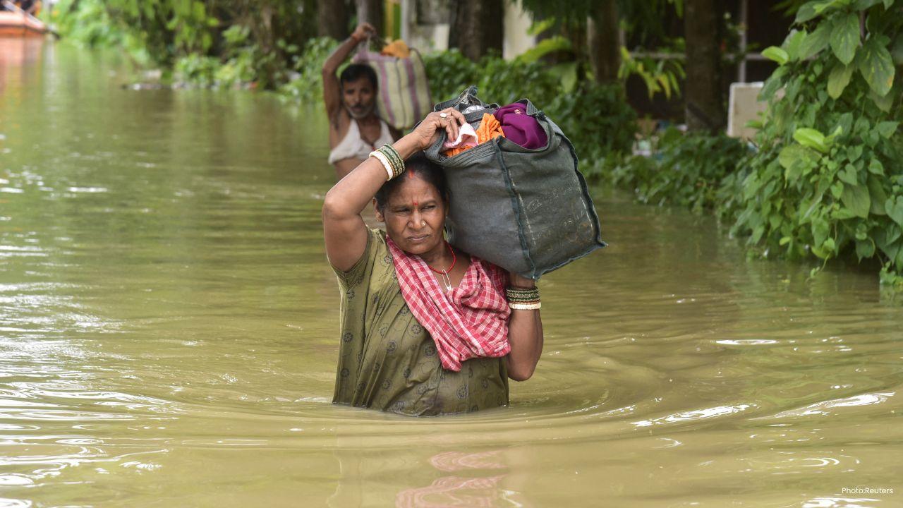
Bihar is facing a fresh Bihar Flood Alert after the Gandak River rose sharply and breached embankments in West Champaran, allowing floodwater to move into nearby low-lying areas. The situation has raised concerns among residents as the river continues to carry a heavy volume of water following intense rainfall in the Gandak basin. The latest developments have created a difficult situation for villages located close to the river and its embankments. Officials are monitoring vulnerable stretches while residents in affected areas remain concerned about further flooding. Reports from West Champaran said the pressure of the swollen river led to breaches in parts of the Champaran embankment around the Bagaha area. Water began moving towards nearby residential and agricultural areas after the protective structure gave way.
The West Champaran Flood situation worsened after multiple breaches were reported along the Gandak embankment. According to reports, one breach occurred near Kharatwa village under the Chakhni Rajwatiya area, while other damaged sections were reported near Fulia Khand and Makri Tesarahiya. The reported breaches together covered a substantial stretch of the embankment and put low-lying settlements and farmland at risk. The force of the water has made the situation particularly challenging because even areas that were not directly affected by the initial breach could face flooding if the river remains at a high level. Residents have been watching the water closely as authorities assess vulnerable points and work to prevent additional damage.
The Gandak River Flood has been linked to heavy rainfall in Nepal's catchment area. The increased inflow pushed the river to exceptionally high levels in the Bihar region. The Water Resources Department reported a discharge of about 5.43 lakh cusecs at the Valmikinagar Gandak Barrage. The discharge remained above 5 lakh cusecs for several hours and stayed above 4 lakh cusecs for a much longer period, increasing pressure on downstream areas. The Gandak's water level at Bagaha was also reported at a record level of 91.25 metres, higher than the level recorded there in 2024. These figures have increased concern about additional flooding in areas located downstream of the barrage.
The threat is not limited to West Champaran. High water levels and heavy discharge from the Gandak have put several districts on alert. The areas facing potential impact include East Champaran, Gopalganj, Saran, Muzaffarpur and Vaishali. The situation is particularly sensitive in low-lying locations where excess river water can quickly spread across fields, roads and residential areas. Bihar's official flood monitoring data also showed several rivers at or above danger or warning levels. On September 29, the Gandak was above the danger level at Rewaghat in Muzaffarpur, while the Burhi Gandak was above the danger level at Chanpatia in West Champaran. The Kosi and Ghaghra were also above their respective danger levels at monitoring stations listed by the state flood forecasting system.
A major factor behind the latest situation is heavy rainfall in the Nepalese catchment of the Gandak basin. Rainfall upstream can rapidly increase water flow into rivers entering Bihar. When that additional water reaches already swollen river channels, pressure on embankments can rise sharply. The recent increase in the Gandak's discharge has therefore created a wider flood risk beyond the immediate locations where embankments have already been damaged. This cross-border river system makes flood forecasting and coordination particularly important during periods of intense rainfall.
Floodwater entering low-lying areas can affect more than homes. Agricultural fields, village roads, local transport and access to essential services can also be disrupted. For farming communities, prolonged waterlogging can damage standing crops and delay agricultural activity. If roads become submerged, residents may face difficulties reaching markets, hospitals, schools and other essential facilities. The immediate concern in affected areas is therefore not only the amount of water already present but also whether river levels remain high enough to cause additional breaches or further inundation.
The administration and disaster-response agencies are closely watching the situation as the flood threat develops. Teams have been working around vulnerable embankment sections, while emergency response arrangements are being maintained in areas facing inundation. Reports have also indicated the deployment of NDRF personnel in parts of West Champaran as authorities prepare for possible rescue requirements. Officials face the difficult task of protecting embankments while also preparing communities for possible evacuation if water levels rise further. For residents living close to the river, authorities generally advise following local warnings and moving to safer locations if evacuation instructions are issued.
Read Also: Healthcare Worker Abuse Cases Nearly Double to 4,200 in Two Years
The combination of a swollen river, heavy upstream rainfall, damaged embankments and high downstream water levels has increased the risk of further flooding. A breach can allow water to move quickly into areas that normally remain protected by the embankment. If the river continues to maintain high discharge, repairing damaged sections can also become more difficult. The situation can change rapidly depending on rainfall and the amount of water flowing through the river system. This is why officials are continuing to monitor river levels and vulnerable stretches.
The immediate focus is expected to remain on monitoring the Gandak, strengthening vulnerable embankment sections and protecting people living in low-lying areas. Authorities will also need to track downstream movement of floodwater because a reduction in water levels upstream does not necessarily mean an immediate end to the danger downstream. Residents in vulnerable villages are being urged to remain alert and follow official instructions as the situation develops.
The flood threat has increased because the Gandak River is carrying a very high volume of water after heavy rainfall in its upstream catchment, while embankment breaches have allowed water to spread into low-lying areas.
West Champaran is among the worst-affected areas, while East Champaran, Gopalganj, Saran, Muzaffarpur and Vaishali are also facing increased flood risk because of high Gandak discharge.
Reports indicate that intense river pressure and the high flow of water contributed to breaches in sections of the Champaran embankment in West Champaran.
No. Bihar's flood monitoring data shows that several other rivers were also above warning or danger levels at different monitoring stations, including the Kosi, Burhi Gandak, Ghaghra and Ganga.





Apple Pay Launches in India With Axis Bank Credit Card Support
Apple Pay launches in India with Axis Bank, supporting eligible Visa and Mastercard credit cards for
Thailand Floods Leave Eight Dead as Heavy Rain Hits 27 Provinces
Thailand floods have killed eight people since September 16, affecting 1.7 million people across 27

OpenAI Says AI Agents Accidentally Posted 53 User Images Online
OpenAI says AI agents accidentally posted 53 ChatGPT user images online, raising new concerns over A

Virat Kohli Says 2027 World Cup Will Be His Last For India
Virat Kohli confirms the 2027 World Cup will be his last for India as he targets one final title bid
Weak Earthquake Hits Kinabatangan in Sabah Early Saturday Morning
A 3.3-magnitude Sabah Earthquake hit Kinabatangan early Saturday. Firefighters found no damage, whil

Europe's Biggest Leagues Demand Sweeping FIFA Reforms
Europe's top leagues demand FIFA reforms, stronger FIFA governance, stakeholder representation and c